NASA releases astonishing photos of Indo-Pak border.
National Aeronautics and Space Administration, NASA on Sunday shared two stunning pictures of the international border between India and Pakistan as seen from outer space on their Facebook. Of the hundreds of yellow clusters of lights, the largest are the capital cities of Islamabad, Pakistan, and New Delhi, India. The lines of major highways connecting the cities also stand out.
The line of lights, with a distinctly orange hue, snaking across the center of the image, is the fenced and floodlit border zone between India and Pakistan. The fence is designed to discourage smuggling and arms trafficking. NASA, in their website, says the image was taken with a 16 mm lens, which provides the wide field of view, as the International Space Station (ISS) was tracking towards the southeast across India.
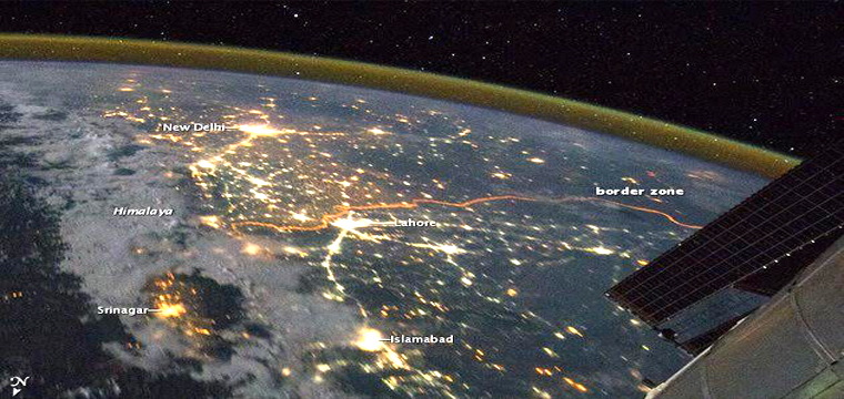
Infact, in 2011, the National Aeronautics and Space Administration (NASA) had shared an image that showed the border zone looking south east from the Himalayas. The Indo-Pak border image that was captured on night was shared on the social media website Facebook on October 3 and since then, millions have viewed and shared it.
The astronaut clicked the photo on the International Space Station where it showed the north-western segment of India in glowing lights. The astronaut who captured the image was “looking north across Pakistan’s Indus River valley”, according to the reports. The snap gave a clear image of how India and Pakistan are separated. The two countries can be seen separated by a thin thread of distinctive orange thread, which is the series of security lights on the border.